


Geoclass Surveying Calculator
Geoclass Surveying Calculator ၏ ရွင္းလင္းခ်က္
Geoclass Surveying Calculator တွင် စစ်တမ်းကောက်ယူခြင်း၊ သတ်မှတ်ခြင်းနှင့် မြို့ပြအင်ဂျင်နီယာအတွက် အစွမ်းထက်သောကိရိယာများ ရှိသည်။
Geoclass သည် အကွာအဝေးနှင့် ဧရိယာအတွက် မက်ထရစ်နှင့် အင်ပါယာယူနစ်များကို ပံ့ပိုးပေးသည်။ ညှိနှိုင်းယူနစ်များသည် မက်ထရစ်နှင့် ဒီဂရီဖြစ်သည်။
Geoclass ကို အသုံးပြု၍ သင်လုပ်နိုင်သည်-
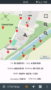
- အမှတ်များစုဆောင်းခြင်း- သင်အမှတ်များစုဆောင်းပြီး UTM Map module ဖြင့်အမှတ်များကိုမျှဝေနိုင်သည်။ အမှတ်များဆီသို့လည်း သွားနိုင်သည်။
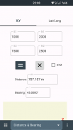
- အမှတ်နှစ်ခုမှ bearing / azimuth အကွာအဝေးကိုတိုင်းတာ။
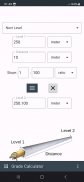
- 3 မှတ်မှထောင့်ကိုတိုင်းတာ။
- သြဒိနိတ်၊ အကွာအဝေးနှင့် ဝက်ဝံ / azimuth မှ လတ္တီတွဒ်၊ လောင်ဂျီတွဒ် သို့မဟုတ် X, Y ကို တွက်ချက်ပါ။
- လမ်းဆုံများ; ရှေ့သို့၊ မျဉ်းကြောင်း - မျဉ်းကြောင်း 3 မှတ်ဖြင့် စက်ဝိုင်း
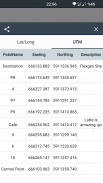
- လတ္တီတွဒ်လောင်ဂျီကျုကို UTM သို့မဟုတ် အပြန်အလှန်ပြောင်းပါ။
- ဒဿမမှဒီဂရီ၊ မိနစ်၊ စက္ကန့်ကိုတွက်ချက်ပါ။
- မြောက်လတ္တီတွဒ်များနှင့်လောင်ဂျီတွဒ်ကိုသြဒီနိတ်. မြေပုံပေါ်ရှိ အကွာအဝေးအညွှန်းဖြင့် သင့်တည်နေရာမှ ၎င်းကို လမ်းညွှန်ပါ။
- မြေပုံပေါ်ရှိသင်၏တည်နေရာမှညှိနှိုင်းရန်လမ်းညွှန်ပါ။
- လတ္တီတွဒ်၊ လောင်ဂျီတွဒ်၊ MGRS၊ X၊Y သြဒိနိတ်များဖြင့် အွန်လိုင်းမြေပုံများတွင် UTM တည်နေရာကို ပြသပါ။
- အချက်နှစ်ချက်မှ သြဒီနိတ်များကို ဖန်တီးပါ။ သင်သည် X၊ Y သို့မဟုတ် လတ္တီတွဒ်၊ လောင်ဂျီတွဒ်တို့ကို အသုံးပြု၍ ထုတ်လုပ်နိုင်သည်။
- ဒေသဆိုင်ရာသြဒိနိတ်များကိုပြောင်းပါ။
- X,Y ကိုသြဒီနိတ်များမှဧရိယာတွက်ချက်
Facebook Page တွင် အက်ပ်အကြောင်း သတင်းများကို သင် လိုက်ကြည့်နိုင်ပါသည်။
fb.me/surveyingcalculator
Geoclass Surveying Calculator - ဗားရွင္း 3.6.0
(08-12-2024)Geoclass Surveying Calculator - APK သတင္းအခ်က္အလက္
APK ဗားရွင္း: 3.6.0package: org.project.geoclassGeoclass Surveying Calculator ၏ ေနာက္ဆုံးဗားရွင္း
အျခား ဗားရွင္းမ်ား


 4.33
4.33 3.67
3.67က႑တူအက္ပ္မ်ား


သင္ႏွစ္သက္ႏိုင္သည္မ်ားမွာ...


